Dhumdhar Kandi : The incomplete dream
" Intense to very intense rainfall in isolated parts of Uttarakhand " is the IMD warning we started our journey with .
6 of us were hopeful that even though we were travelling to Uttarakhand, we will be nearer to kinnaur / Spiti region which is comparatively dryer and we might just escape nature's fury.
We were about to find that out.
If you are an outdoor person , you would know that September is the best month for Himalayan treks. We believed in this too all these years. Dhumdhar Kandi was on our wish list for the past few years but wasn't executed due to the pandemic. We started planning for it in June.
In the last few years the weather in Sept has been inconsistent. We had experienced this during Buran Ghati and Sin La treks a few years back but considering the length of the trek and availability of team members , early sept was the only window we had.
Post Ganpati Festival , we reached Mussoorie , spent a few days acclimatizing ourselves with small hikes like lal tibba , Buddha temple and travelled for close to 10 hours to reach Sankri on 11th Sept.
Weather looked alright when we reached but at night we were welcomed by thunderstorms and rains which lasted for a few hours. The morning was gloomy as well , our fears were about to come true.
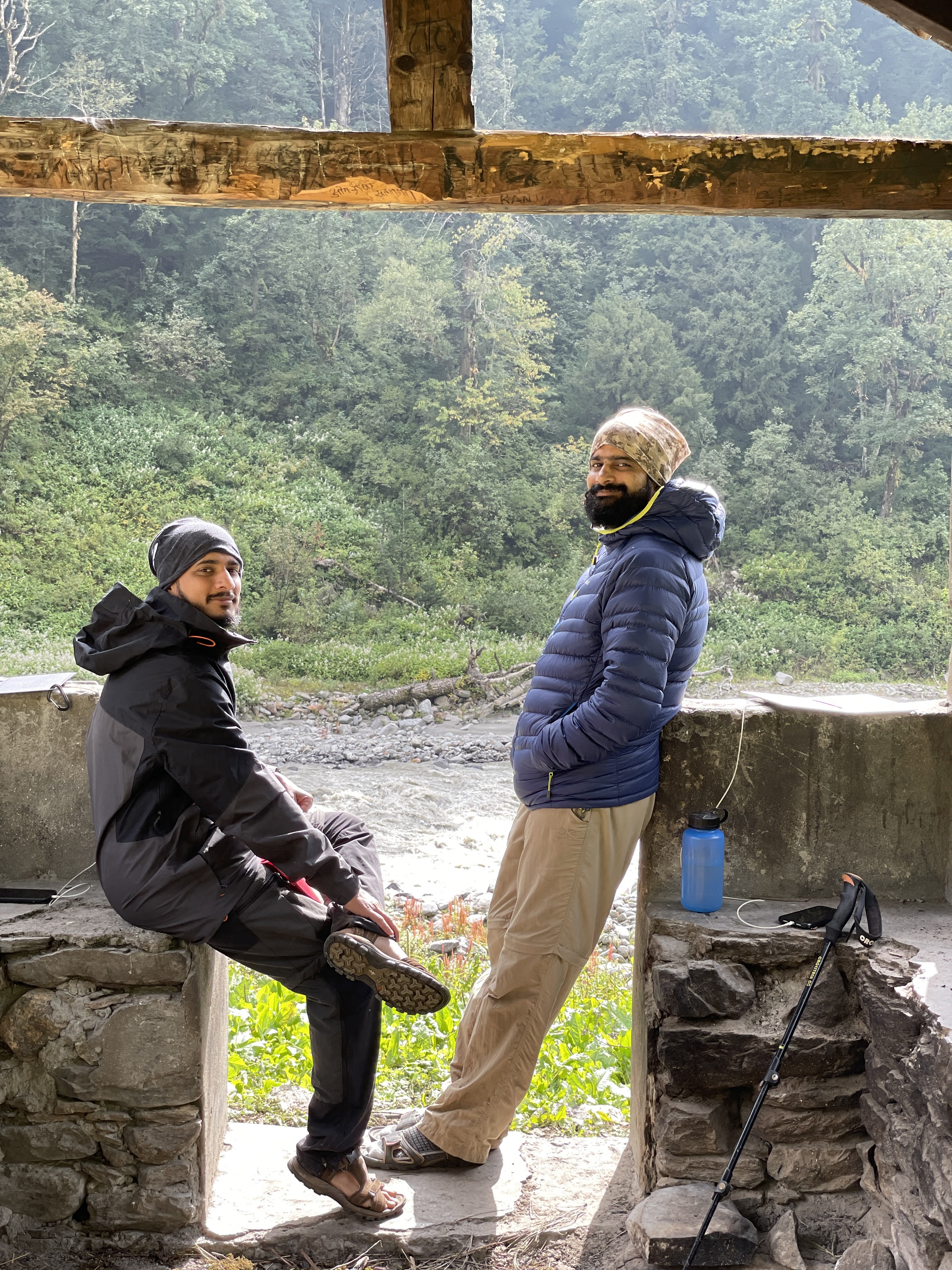
Day 1 : Sankri ( 6300ft) to Taluka ( 6700ft ) to Seema ( 8314ft)
Dhumdhar kandi pass is in the Har Ki Dun region , so for the first few days our route would be the same as the Har Ki Dun trek route. Taluka is a small village about 15kms from Sankri is also the last motorable village in Govind Wildlife Sanctuary. This would be our starting point.
Our heavily loaded Mahindra Camper was waiting at the entry gate of the wildlife sanctuary , tour operator Govind was inside to get the passes. It took a while , the forest official was unwilling to issue passes beyond Kyarkoti (for no reasons given) , after a while “ Adjustment” was made and we were let go.
The 15km road to Taluk is still under construction , the contractor was about to blast a section of hill which would have closed the road for the day , our vehicle was allowed to go through on condition that it must come back within 20 mins , and the blast would be postponed until then. We had to hurry.
Our expert driver managed to drop us in next 10 mins and we are till day hopeful that he evaded the blast 😜
Taluk to Seema would be the longest distance of the trek , around 15kms while gaining close to 2000ft height , most of the path ascends gradually. Har Ki dun is one of the oldest and most frequented trek routes in India , we knew that the route would be well mapped.
 |
| Our camper at the entry point |
 |
| Taluka Village on the banks of Supin river |
 |
| Curious villager |
The trek route follows Supin river for first 2kms and then very gradually starts ascending along the mountain and into the dense forest. This forest is an ancient one , you can make it out from the variety of large trees it has. It's full of pine , Maple, Rhododendron , Arjun and other huge trees , some reaching heights of over 100 meters. And then there is a reach variety of grass , bushes and other small plants. Such ecosystem takes thousands of years to flourish , luckily it's still intact and I hope it stays and grows for another thousand years to come.
 |
| For first 2-3 kms the path moves along the banks of Supin and then enters forest |
 |
| Cholai Fields , a grain which makes for tasty roti , Men however are dreaded by cholai , making dough from these grains is an experts job , left to the subject matter expert ladies |
 |
| Crossing Supin |
 |
| Path then leads to an ancient forest full of huge trees |

 |
| typical Garwahli picnic , visit the village at lower height |
 |
| Around 10kms mark you will reach Gangad village , the main village is on the other bank but these small dhaba's will warm you with tea and Buransh juice |
 |
| Entering Seema village after close to 5 hrs walk covering 15kms |
 |
| View from the bridge near village seema , Osla is on the right bank |
 |
| Making abandoned GMVN guest house our home for the night |
Took us close to 5 hrs to reach Seems , covering 14.5kms. We decided to use an abandoned GMVN rest house for our stay. Wooden floors ensured comfy stay , windows were broken but still good enough to keep cold wind at bay. Beautiful Osla village was visible on the other bank of the river , Situated at 300-500ft higher altitude than Seema. If we were doing Har Ki Dun trek , Osla would have been our stay for the night.
Drizzle started after 5PM and continued till late night , grew stronger by mid-night , but in the morning we had clear weather
Day 2 : Seema to Devasu Bugyal to Rain Basera
Today we were told , would be one of the most scenic walks of the trek. We were moving away from the usual Har Ki Dun path , hence the route was less frequented by mules , moving along Supin for a while before leading to Devasu Bugyal at 10,000ft.
 |
| Maldadu lake waterfall |
 |
| clear weather and better views , what else you need ? |
 |
| Entering devasu bugyal at 10200ft |

 |
| View from Devasu bugyal , Black peak on left and bandarpunch behind the pine tree |
Rain basera is a forest dept built Rain Shelter , good enough to hold 2-3 people at max . We had just pitched our tents for the night when the downpour started , it lasted for an hour or so , slowly reduced to light drizzle and the ended up opening up an absolutely gorgeous views of Black Peak ( Kala Naag ) , Garud and Bandarpunch ( Monkey Tail ) mountains.
 |
| Rain shelter or Rain Basera campsite |

 |
| enjoying clear weather , Ninad and Dattu |
 |
| Garud peak |
 |
| Beechu Kaata ( Scorpion Sting ) , touch it and gives you pain for 2 hours , boil it and makes a tasty vegetable |
Day 3 : Rain Basera to Ruinsara Taal
Waking up early in the mountains to see the sun rise has been an habit , at 5:30 AM in the morning weather looked absolutely clear , we saw the first rays of light touching Black peak , unveiling nearby mountains one by one , lighting the Supin river basin at the same time , the sheeps and shepherds dogs in the river basin lazily responded to the light , waking up slowly one by one.
“ Never miss the sun-rise in the mountains “
.jpeg) |
| Black Peak or kaal naag on left , Garud in the middle and Bandarpuch to the right. dhumdhar kandi is at the base of Kala Naag |

 |
| Weather changes full 180 degrees |

 |
| Shepherds |
Took us close to 3 hrs to reach Ruinsara taal , weather was not very promising , clouds were everywhere , fortunately it wasn't raining. There is an old forest hut with grass flooring , we thought it would make a good platform for our sleeping bags.
Just as if the alarm clock went off , at 3 PM , it started raining , gaining more and more power every hour. Reminding us of the IMD warning , “ if it continues raining like this , it would be difficult to move ahead tomorrow “ Randev our guide confirmed what we were thinking.
On the other bank of the river , we saw a few local porters moving quickly towards the Bali Pass ridge. We were amazed at how quickly they moved. We believe that people in the mountains are born with an additional pair of lungs. Their agility and strength at these higher altitudes is unmatched.
By 5 PM rains had gotten stronger , water had started dripping in the old hut , grass floor was about to get converted into a pond , Randev and team quickly pitched our kitchen tent inside the hut to protect our sleeping area and have some cover on our heads at night.
 |
| The forest hut which protected us |
 |
| Ruinsara taal deity |
 |
| Ruinsara Taal , a small glacial lake |
 |
| Men who make everything look so easy |

Day 4 : Stranded at Ruinsara
It kept pouring in throughout the night , next morning they gathered even more strength. We instantly knew that we have to utilise one of our two reserved days and hope that the weather improves the next day.
We retired to the comforts of our tent , thankfully Ninad had Dollars Trilogy movies in his phone for us to bring on for the rest of the day.
 |
| Movie time |
 |
| Char Sing Patangla , a holy peak said to be resting place for Goddess Kandara Rani , you are not allowed to wear boots from its base onwards , hence unsalable. Locals say there are many wild animals and deers near this peak , if you kill any of them you have to donate one made up of gold to get rid of the blindness which will follow |
 |
| Eat , sleep , movie , repeat |
Day 5 : South Indian Movie marathon
Loud thunderstorms and rains kept waking us up at night. At 4:30 AM in the morning , the rain had stopped , stars were visible for the first time , and the full moon was up. On our left we could see Garud peak and the bali pass ridge. Looks like we are going to move today for sure , or so we thought.
By 6 AM however the situation had changed completely , clouds were back and so as the rains , visibility was near to zero , we could barely see the waterfall 200m away.
Situation was even bad at the other end of the river near bali pass base camps , we were fortunate to have shelter over our head , the bali pass teams were at the merci of their tents , we were not sure how much tents could take of these incessant rains. We hoped well for them. None of us were going anywhere today.
Dattu managed to get a few movies transferred on his mobile from our porters , we spent the day watching dubbed south indian movies like “ Ek Khiladi “ , “ Khatarnak Policewala” , “ inspector Rama Rao “ really tested our patience. It was more torturing than the weather outside which by now had refused to improve.
By now we had used up our 2nd reserve day as well. We had a long discussion with Randev on what he thinks the condition would be like on the higher camps and most importantly at the pass.
Dhumdhar kandi pass is notorious for falling rocks , shooting stones and ice slides , may the the noise falling rocks make gives the pass its name “ Dhumdhar”.
We got the news that Bali pass team had seen glacier sliding down near kyarkoti side just few hours back which made Randev look even more worried “ if its raining here , it's snowing at kyarkoti and pass for sure , if we do not get clear weather for next 2-3 days the ice at the pass won't melt and it would be very difficult to cross the pass then with the equipment we have “ Randev was candid about what holds in store for us.
We all agreed that we will move to higher altitudes only if we get very very clear weather next morning , We knew that IMD had predicted that this weather would continue till 19th , if that forecast holds true next morning , we had every reason to believe that situation at higher camps will be even worse and possibility of crossing pass will reduce every hour it rains.
Day 6 : Ruinsara Taal to Osla ( 8700 ft)
Over the last few days the weather has only worsened further. Yesterday we received a group of porters from Kyarkoti and their narrations were not very promising. There was a heavy snowfall in Dharo Ki Odri region ( the next camp after kyarkoti at 15500ft).
It was almost certain that crossing “Dhumdhar Kandi” won't be possible unless there is clear sunshine for 2-3 days, at that moment this was a remote possibility. We had to turn back.
Randev suggested that we should go to Osla for the night stay , all of us were mesmerized by Osla’s beauty when we had seen it from Seema so none of us needed a second invitation.
Ruinsara taal to Osla would be a 15-16km walk and rains would make it even tougher but that was our only chance.
Rain started getting stronger just before the Rain basera campsite. We kept walking , we knew once the rain starts , it's not going to stop quickly.
Instead of taking a left at the Devasu Bugyal bridge crossing , We went straight into the jungle and across the river. The path was not used as much , it reminded us of the jungle paths we have here in Sahyadri.
The tall grass carrying water from the rain above was now passing the same water into our boots and socks , making it tough to walk but the beauty around kept us enthralled.
The day kept reminding us of the monsoon hikes we do here in sahyadri , the only difference is here in western ghats temperatures are not that low so even if you are drenched in rain , chances of hypothermia are next to none. Here however in the Himalayas , at 8000ft height , that remains a risk.
“ Keep walking “ that's the only remedy for hypothermia and we did exactly that.
Took us close to 5 hrs to reach Osla and into the comforts of the wooden cottage.
 |
| Hau flowers as called locally or Asian Knotweed flowers |


 |
| tea break |
 |
| comforts of the homestay |
Day 7 : The drama continues …. ( Osla to Sankri )
Today would be the last day of our trek, so far it has not gone the way we wanted to but we enjoyed every bit of what was on offer. The toughest thing to do on the last day was “ Getting back into our wet clothes again “ .
But to our surprise we were greeted by some sunlight in the morning and by the time we started walking , Osla’s beauty was at its best.
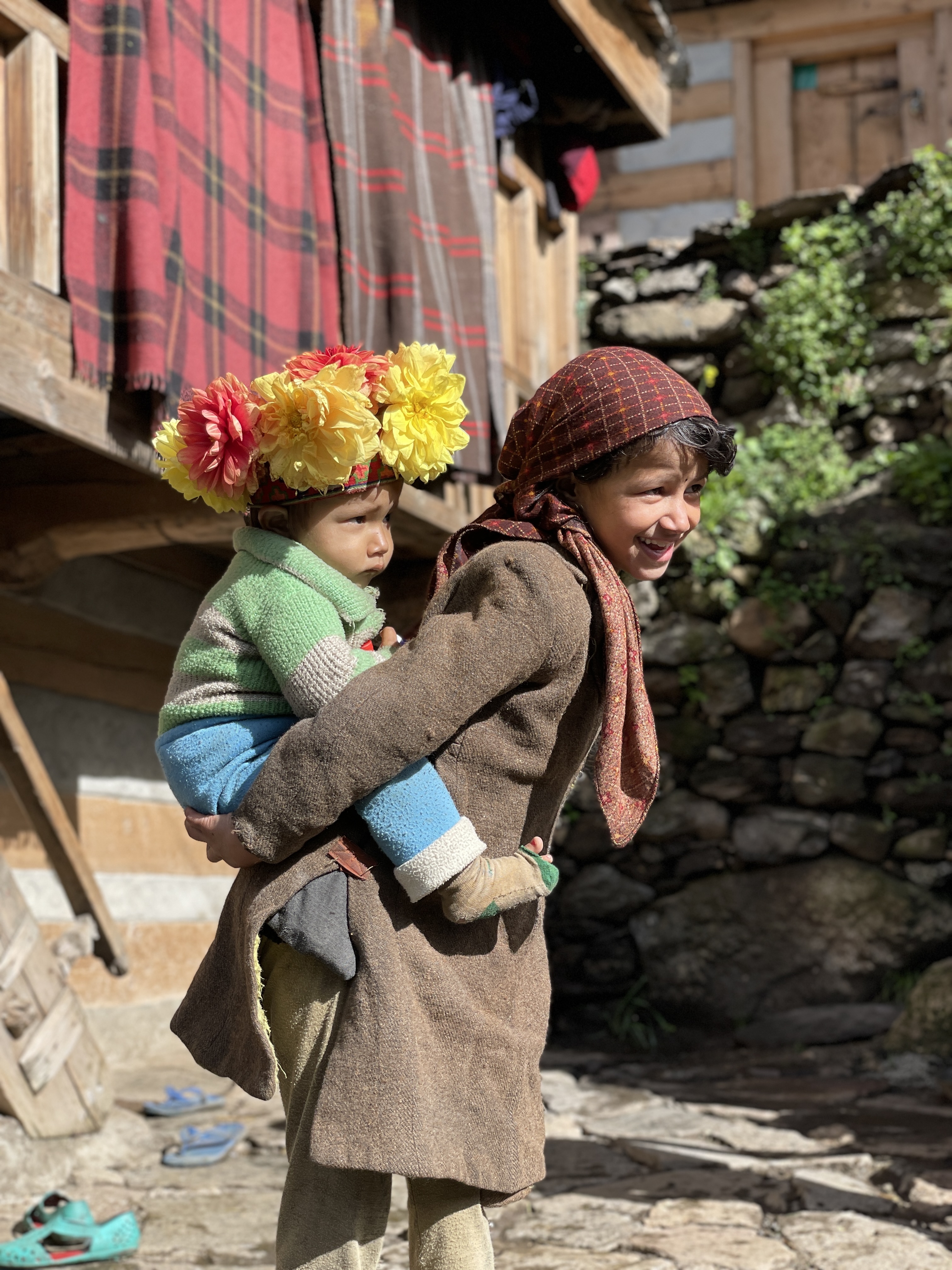
The Osla story
Osla is a very old village , probably a thousand years old , Har ki dun is the same route Pandavas took on their way to heaven. And the stories from Mahabharata are pretty much folklore in this region.
Osla also has a “ Duryodhana” temple while the people here refused to believe that this is the same Duryodhana , the villain from Mahabharata , they worship him as someshwar ( Mahadev).
However this region as per the Mahabharata could be part of Trigarta kingdom , which was an Kuru ally in the great war. The peculiar thing about this temple is that it opens only at night.
However this is not the Osla story I wanted to tell , here is the one as told by Randev our guide ( all our porters , guides and tour operators were from Osla village only ).
Osla’s protector daity is a Naag ( cobra ) , there is a ground left open in his honor at the end of the village. Many many years ago , one day the deity warned the villagers that there will be a heavy flood and landslide so they should vacate the village at once. The village used to be a little to the right of what it is today , just in front of the waterfall.
The deity’s warning came a bit too late , the entire village was wiped off , only 4 men survived. Nearby villages saw this as an opportunity to grab well farmed lands. 3 of the men were killed. One managed to hide in the waterfall and survive. He left the village in the dark of the night.
The survivor settled elsewhere for the next 5-6 years , got married, had kids , managed to form new bonds , get allies and came back to Osla . And thus reclaimed his rightful place and land. In today's Osla, everyone has common surname “ Rana “ , 150 families flourish here now.
There is no way I can confirm the authenticity of what happened here , but it does make a good story.
Till today Osla can only be reached on foot , most villagers here still struggle with Hindi or any other mainland language. But now the village has wifi ( a solar powered one thanks to BSNL ) , active presence on social media and do watch south indian movies 😀
We were dumbfounded by the beauty of people here and amazed at the hard work men and women put to survive in these harsh conditions.
We also met a group of doctors from Kerala , who had set up a medical camp here for the past month and were now going back.
Osla remains the most beautiful memory of this trek.
 |
| Har Ki Dun peaks |
 |
| Osla you beauty !! |
 |
| sunshine finally |
 |
| Duryodhan or Someshwar temple |


 |
| 25kgs easily done 🙏 |
 |
| Malta and Buransh Juice |
 |
| Choteer wild berries |

Me and Ashtaputre kaka were just 200 meters away from Taluka when the rains started again. We pushed through and reached the safety of a small hotel in Taluka. Others were about 30 mins behind and had to take their rain protestors out.
While we were enjoying omelette , Randev came in looking a bit worried , “ Khacchar nadi main gir gaya “ ( Mule fell into the river ) . On a narrow pathway two mules came face to face , both heavily loaded one slightly stronger managed to push our mule into the river , poor animal battled ragging Supin river for 2 kms , our porters Randev & Manoj literally ran 2km sprint and jumped into the river to save the animal and the luggage it was carrying.
One of the luggage was our additional luggage which we had offloaded for the trek , luckily some of us had only offloaded an extra pair of clothes , some of us had offloaded all their spare clothes and now the luggage bag was just back from 2km long river rafting. Despite the dry bags and plastics all clothes were wet.
A big lesson we all learned , if you are off-loading your luggage , make sure that the bag you are carrying is your survival backpack , you should be able to survive with what's in that bag for the entire trek in case the accident like this happen (and this happens in the mountains)
Nonetheless , We safely made it back to Sankri with the promise that we would come back to this fascinating region again for Dhumdhar Kandi.


Embark on a thrilling journey to the Biggest Cave in the World with Explurger: Get Out Get Social! Add this breathtaking destination to your bucket list, track your travels automatically, and share your adventure with fellow explorers. Discover new places and connect with travelers while earning rewards along the way. Explore the world’s most stunning cave with Explurger today!
ReplyDeleteAbsolutely loved this post! If you're planning a dream vacation, Seabeach Delight is your one-stop destination for the best Andaman Nicobar package for family. Whether you're seeking relaxation or adventure, they offer customized Andaman and Nicobar tour packages that suit every traveler's needs. Couples looking for romantic escapes will love their Andaman tour packages for couple, and if you prefer to book your own stay, check out their flexible Andaman tour package without hotel. For honeymooners, the honeymoon tour packages in Andaman promise unforgettable memories. Call +91-9679597659 or +91-7063995196 to book your ideal getaway today!
ReplyDeleteReally enjoyed reading this article. The information about best andaman tour package is very helpful. Such packages can vary widely depending on the destination, budget range, trip duration, and the couple’s expectations. Appreciate the detailed explanation!
ReplyDeleteLooking for the best andaman nicobar package for family? Seabeach Delight offers affordable, well-planned trips with family-friendly stays, sightseeing, and fun activities. Book now at https://www.seabeachdelight.com/or call 7063995196 for a hassle-free vacation!
ReplyDelete